Thursday, June 28, 2012

Karen’s Travel Blog: United Kingdom and Ireland

Welcome to Karen Toh's Travel Blog!


I started this blog sometime in 2009, but never got around to completing it. Since I recently visited the UK and Ireland in 2010 for the third time, I decided it was time to update the entire blog. I've thus added some of own pictures from 2004 (2nd trip), plus included content and pictures of the places I visited/researched on for my 2010 vacation. I’ve also supplemented some pictures from Wikipedia to make this blog interesting. :p


Traveling in the United Kingdom was somewhat like coming home. It felt familiar, maybe because Malaysia, was colonized by the British before we celebrated our independence on August 31, 1957. We similarly drive on the left, are familiar with the real estate in  monopoly; and have studied English literature.


P.S. Should you like to view my photos, you can do so at my Webshots Community Album. You can also read my other Travel Blogs here.

Travel Blog References
·         Contents compiled, written or edited by Karen Toh Guek Bee.
·         Wikipedia http://en.wikipedia.org/
·         Great Britain, Eyewitness Travel Guide, Dorling Kindersley Ltd, 2003
·         Britain, Lonely Planet, 1999
·         Let’s Go BritainIreland, Harvard Student Agencies, 2000

Photography Images:
·         Courtesy of Wikipedia.com
·         Copyright Karen Toh, 2010 and 2004

Part I - England

Windsor Castle's Upper Ward - The Quadrangle, Windsor, Photo Image © Wikipedia
Windsor Castle's Round Tower, Windsor, Photo Image © Karen Toh, 2010
Windsor:
Windsor Castle dates back to the time of William the Conquror, and continues to be the oldest and largest castle in the world to be occupied. It is one of the three official residences of Queen Elizabeth II, and that of Queen Victoria and Prince Albert during Queen Victoria’s reign. Pictures don’t do the grounds justice, unless one takes an aerial view of the castle.

Highlights:-
- State Apartments
- Queen Mary's Doll House
- Changing of the Guards
- Albert Memorial Chapel
- Round Tower
The Royal Crescent in Bath, Photo Image © Wikipedia
Bath:
Bath has always been a favorite amongst the locals, as people visit bath for its water – from the hot springs. The Roman Baths (Museum) is one of the best preserved archeological ruins, which give you an insight into the olden day spas of the rich. The town itself is very pretty, and is best seen on foot.
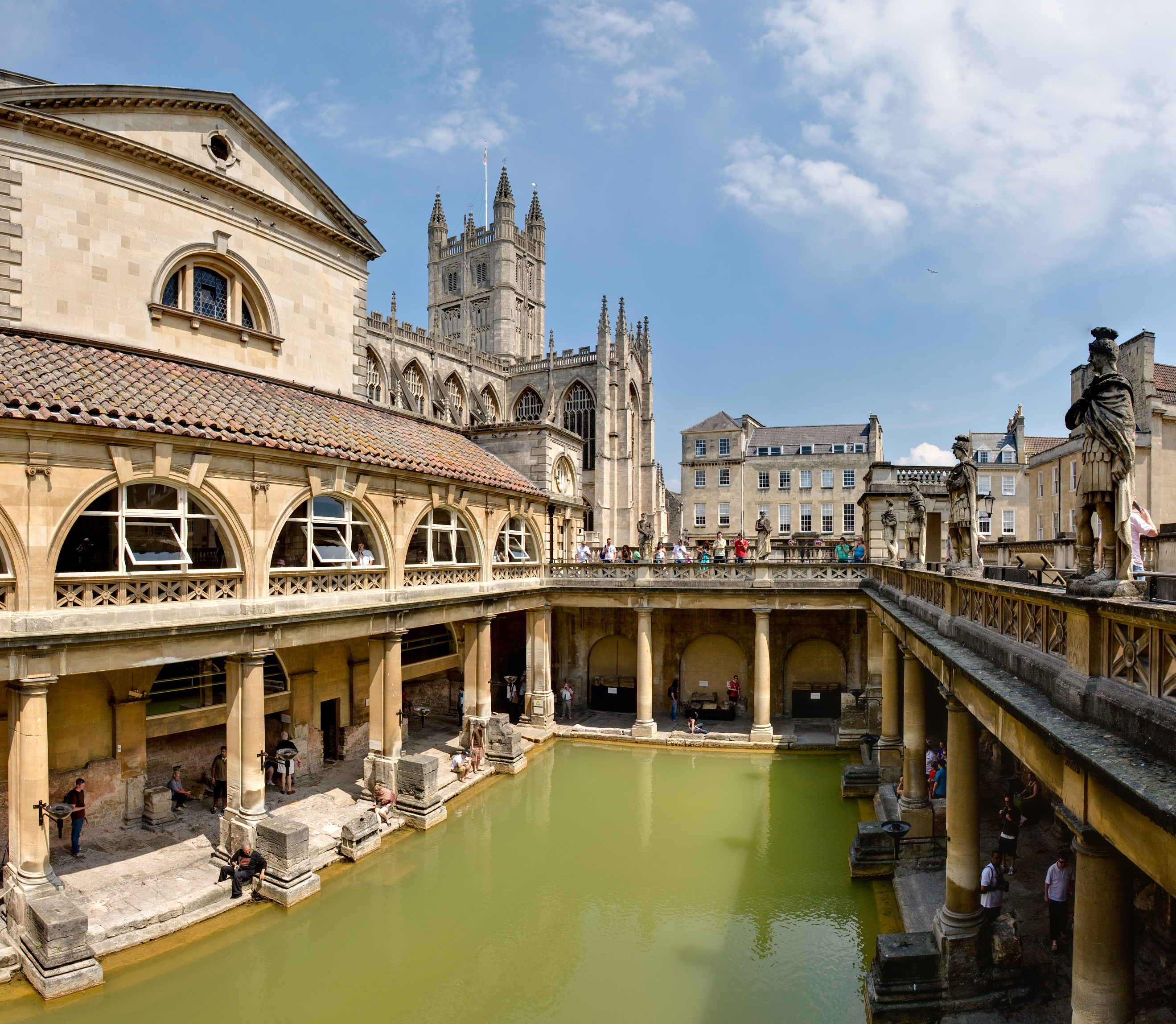
The Great Bath at the Roman Baths, Bath, Photo Image © Wikipedia
In my last two trips in Bath, I've found it a very charming city, but never did get a chance to have a good overview of this World Heritage Site. I may yet have to return for a longer visit. :p

Bath is located at the bottom of the Avon Valley, and near the southern edge of the Cotswolds, a range of limestone hills designated as an Area of Outstanding Natural Beauty. The surrounding hills give Bath its steep streets and make its buildings appear to climb the slopes. The water which bubbles up from the ground, as geothermal springs, percolates down through limestone aquifers where geothermal energy raises the water temperature. Under pressure, the heated water rises to the surface along fissures and faults in the limestone. 

Jane Austen Festival 2012   Photo Image ©  Maria Grazia
One of the interesting events in Bath is the Jane Austen festival that takes place once a year in September. Fans are transported back in time, dressing up in period costumes attending soirees, theatre, concerts, participating in walking tours as well as ballroom dances, etc.  Women often change several times a day - morning dresses, afternoon tea dresses, and ballroom gowns. Men who participate are dressed as Gentlemen, Soldiers or Sailors.

Wiltshire:
The county of Wiltshire must be explored, as it boasts rolling chalk plains. It is this region that many come to visit – the prehistoric sites of Stonehenge and Avebury, as well as the cathedral at Salisbury. Take a walk around Avebury and look out for the Sarsen stones, which surrounds the village, or explore the mysterious secrets of Sillbury Hill, known for its prehistoric burial mound.
Salisbury Cathedral, Photo Image © Wikipedia
- Salisbury is famous for its cathedral, the Cathedral Church of the Blessed Virgin Mary, that has the highest spire in Britain. It is worth a stop for its spire is awesome.

England's Famous Rock Group, Stonehenge Photo Image ©   Karen Toh, 2010 
- Stonehenge is world renown as a sacred site. This prehistoric site consists of a ring of enormous stones. Some of these stones weigh up to 4 tons each, and were brought in from South Wales, some 250 miles away.

A walk around the perimeter of Stonehenge is a must. You must rent the audio guides before you walk in, as there are no other guided tours. The best time to see this site is at sunset, just before they close, and because of it’s ancient rites, visits during the summer and winter solstice could mean that you would have to brave the crowds.


Beware of the birds.. Smaller than blackbirds, with a short tail, pointed head, triangular wings, starlings look black at a distance but when seen closer they are very glossy with a sheen of purples and greens. Their flight is fast and direct and they walk and run confidently on the ground. Noisy and gregarious, starlings spend a lot of the year in flocks.

Chester:
On your way to Lake District whether you’re coming from London or Manchester, I suggest you make a day trip to Chester.

Chester was a quaint little town, that has been fortified by a 2 mile circuit of red sandstone wall that dates back to the Romans. To get a feel of Chester, one should take a clockwise walk along the wall, starting with the Eastgate at the Eastgate Clock.

The Chester Rows, Photo Image © Wikipedia
One of the highlights in Chester is ‘The Rows’, the timbered buildings known as The Chester Rows. These are two tiered shopping streets which are quite the thing on a wet day. One can literally walk on the upper gallery from one end to the other, and walk back on the lower gallery. Obviously the Romans were ahead of their time in terms of designing a shopping mall! Today, you’ll find curious little shops or boutiques.

Lake District:
Of hills and dales, this part of England is truly inspiring. The combination of mountain, lakes, sky and the occasional glimpse of the sun will reward the photographer, or provide a moody shot. This part national park truly deserves at least several days worth of exploring. The best way to take in the Lake District is by walking, cycling or driving around. If you have a car, do note that parking spaces are rather limited in the peak season and on weekends. During these periods, traffic jams are common.

There are two main bases – Keswick in the north, and Windemere in the south. Here are some pictures to convince you to visit the Lake District!

- Windermere is the largest natural Lake in England, and is located within the Lake District National Park. Like most of the Lake District, the lakes and its valley were carved out by Glaciers during the Ice Age.
Bowness on Windemere, Photo Image © Karen Toh, 2004
If you’re in Windemere, do make a visit to The World of Beatrix Potter in Bowness. Here you’ll find Peter Rabbit and his pals, who would love to accompany you home in various forms – soft toys, story books and more. Or visit Hill Top, the farm house near Sawrey, where Beatrix wrote many of her stories.
Peter Rabbit, Photo Image © Parker Mitchell


- Ambleside is located at the northern end of Lake Windermere, close to Waterhead, between Wansfell and Loughrigg Fell. Ambleside is also a convenient base for touring the central areas of the Lake District, as it is a short distance to Grasmere and the Langdale valleys by car or bus. Take a short walk through the woodland to the Stock Ghyll Waterfalls or walk from Ambleside to Waterhead, where you can connect onto Lake Windermere Steamers for a Lake Cruise.


- Grasmere is charming village, and was the place where poet William Wordsworth found his words with his greatest poems. Take a guided tour his Dove Cottage, or visit Rydal Mount where he lived.

Country Estate @ Hawkshead, Lake District, Photo Image © Karen Toh, 2010
- Hawkshead can be found south of Ambleside, close to the hamlet of Near Sawrey. Beatrix Potter owned a farmhouse near this area, and it was here that she adopted a variety of animals – dogs, cats, and even a pet hedgehog named “Mrs Tiggywinkle”.


Castlerigg Stone Circle, Photo Image © Wikipedia 
- Keswick itself is a good base for the northern lakes. One of the highlights in this village is the ancient stone circle of Castlerigg, which is thought to be older than Stonehenge, dating back about 2,000BC. It is worth the hike along the river and up the hill to this ancient site.
Reflections @ Keswick, Photo Image © Karen Toh, 2004
- Derwent Water is one of the bigger lakes within the Lake District, and is accessible from Keswick.

Derwentwater from the northern shore near Keswick, Photo Image © Wikipedia
- Wast Water is one of the deepest lakes in England. It is one of the finest examples of a glacially 'over-deepened' valley. The surface of the lake is about 200 feet above sea level, while its bottom is over 50 feet below sea level.

Carlisle and Hadrian’s Wall:
Carlisle is known as the last English city before the Scottish border, and is located in the North Western part of England, about 16 km from the borders of Scotland. It has a rich history in warfare, and has a Castle, Church and a City wall!
A Long Wall along Hadrian's Wall, Birdoswald, Photo Image © Karen Toh, 2004
Hadrian, the Roman Emperor, built a wall (stone and turf fortification) stretching from coast to coast to keep the barbaric Pictes, and ancient Scottish Tribe out. Today, many of these roman legacies remain, along with Birdoswald, a Roman Fort which can be found on the way from Haltwhistle to Brampton. During the spring & summer, many hikers take up the challenge to walk the wall.
Christopher Wren's south front built for William and Mary viewed from the Privy Garden, Hampton Court Palace, Photo Image © Karen Toh, 2004
Hampton Court:
Hampton Court Palace was originally built for Cardinal Wolsey, a favourite of King Henry VII. As Wolsey fell from favour, the palace passed to King Henry, who enlarged it. 


Visitors to the Palace can now step back in time, as some of its characters come alive at Hampton Court!


London:
Ah, London is a city that grows on you. I've visited this metropolitan city three times now, and still have not had enough of it!! From history to pomp and ceremony to shopping, you can have it all in London. The best way to see London if you’re a first timer, is to take the double decker tour buses. Most tour companies have live guides or audio guides. You should also take a thames cruise. Take time to familiarize and prioritize what you wish to see.


Do not miss the following:-
London Eye, London, Photo Image @ worldtripper3   
- The Tower Bridge and the Tower of London (and the Beefeater Tours are a must!)
- Buckingham Palace and the Changing of the Guards (and state apartments/Galleries, if you have the time!)
- St. Paul’s Cathedral and Westminster Abbey
- Tralfagar Square
- The Houses of Parliament and the Big Ben
- Shakespeare’s Globe Theatre (Replica)
- The London Eye
- Covent Garden
- Oxford Street Shopping
- Broadway Theatre
- Thames Cruise
- Museum (are free!) - British Museum, Tate Modern, etc.


Day Trips outside of London that you shouldn’t miss:
- Greenwich
- Bicester Village Outlet Shopping

Part II - Scotland

The old blacksmith's shop at Gretna Green, Photo Image © Wikipedia
Gretna Green:
Gretna Green is infamous for runaway marriages that were performed by its local blacksmith. Gretna is located in the south of Scotland. Today, this picturesque village is frequented by tourists on their way to Edinburgh.

Edinburgh:
Like London, the capital of Scotland – Edinburgh, has a rich history, mystery and tradition. It is perched on several extinct volcanoes and rocky crags with the Firth of Forth to the north.

- The Palace of Holyroodhouse, or informally Holyrood Palace, founded as a monastery by David I of Scotland in 1128, has served as the principal residence of the Kings and Queens of Scotland since the 15th century. The Palace stands in Edinburgh at the bottom of the Royal Mile.

Edinburgh Castle in Autumn, Photo Image © Wikipedia
Stirling:


Originally a Stone Age Settlement, Stirling has been strategically significant since at least the Roman occupation of part of Britain, due to its easily defensible hill (latterly the site of Stirling Castle) and its commanding position beside the River Forth. Stirling Castle sits atop the Castle Hill, a volcanic crag, and is surrounded on three sides by steep cliffs, making it easily defensible. This fact, and its strategic position, have made it an important fortification from the earliest times.
The Wallace Monument, near Stirling Castle, Photo Image © Wikipedia
The renaissance Chapel Royal on the north side of the upper court was used for the coronation of the Queen of Scotland, Mary Queen of Scots, when she was 9 years old, in 1543.

Near Stirling, on summit of Abbey Craig, stands a tower known as the Wallace Monument, that commemorates Sir William Wallace, the 13th century Scottish Hero.
The Balmoral Castle, Photo Image © Wikipedia
Balmoral:
Balmoral Castle is a large estate house situated in the area of Aberdeenshire, Scotland known as Royal Deeside. The estate was purchased by Queen Victoria's consort Prince Albert, and remains a favorite summer royal residence.

Inverness:
Inverness lies at the mouth of the River Ness as it flows into the Moray Firth in north-east Scotland. The river flows from nearby Loch Ness and the Caledonian Canal connects Loch Ness, Loch Oich, and Loch Lochy. To enjoy this city, take a walk along the river Ness.

It is the base of which one would visit take a day trip to visit the Urquhart Castle and cruise up the Caledonian Canal from Loch Ness.

Loch Ness:
The Loch Ness is a large deep freshwater lake in the Scottish Highlands, extending for 37km southwest of Inverness. It is most well known for its legend of the Loch Ness Monster, affectionately named Nessie.
Cruising on Loch Ness. Photo Image © Karen Toh, 2004
Many tourists take trips to Urquhart Castle, which was in it’s day, one of the largest strongholds of Scotland in the medieval times. 
Urquhart Castle along the Loch Ness. Photo Image © Karen Toh, 2004
The castle sits beside Loch Ness in Scotland along the A82 road, between Fort William and Inverness, and is the perfect point to take a boat cruise back to Inverness through the Caledonian castle.


Fort William:
Fort William lies on the shores of Loch Linnhe beside the mouth of the rivers Nevis and Lochy. It is the largest town in the highlands and the second largest settlement behind the city of Inverness.
Fort William, Scotland, Photo Image © Karen Toh, 2004
Fort William is a good base to climb Ben Nevis, and is the on the Road to the Isles. The Ben Nevis is the highest mountain in the British Isles, located at the western end of the Grampian Mountains in the Lochaber area of Scotland.

The Ben, as it is affectionately called by locals, is a favourite destination for walkers and climbers, as it suitable tracks on the south side for walkers and high cliffs on the north face for climbers and mountaineers.

Part III - Wales

Tintern Abbey, Wales, Photo Image © Karen Toh , 2010
Tintern:
Tintern Abbey a spectacular ruin, was the first Cistercian abbey in Wales, founded in 1131 in the beautiful Wye valley. It was during the reign of King Henry VIII, in one of his political actions in which the king created a policy that began the Dissolution of the Monastries, invoking total control over the church in his realm.  Tintern Abbey was surrendered to the king’s visitors on 3 September 1536, and as the monks left the abbey in that late summer, a way of traditional monastic life ended after nearly 400 years. With the roofs gone and the windows smashed, the shell of the abbey fell into decay.

Cardiff Castle Clock Tower, Wales, Photo Image © Wikipedia
Cardiff:
Of Roman Origins, the city of Cardiff or Caerdydd (Welsh) is the capital of Wales.  Much of its Roman remains now lies beneath Cardiff Castle, a medieval castle built in the 11th century. The castle was begun by Willaim the Conqueror on his return from St David’s in Pembrokeshire. 
Picturesque Tenby, Photo Image © Karen Toh, 2010
Tenby: 
Tenby is a walled seaside town in Pembrokeshire in South West Wales. It’s notable feature is its 4km of sandy beaches, its 13th century medieval town walls.


St David’s Bishops Palace and St David’s Cathedral, Photo Image © Visit Pembrokeshire
St David's:
St David’s and the Cathedral Close, known as St David’s is a city and community located in Pembrokeshire on the St David’s peninsula. It is the final resting place of Saint David, the country’s patron saint.

Aberaeron Harbour, Wales, Photo Image © Karen Toh, 2010
Aberaeron:
Aberaeron is a seaside resort town in Wales, built around the estuary of River Aeron, which has been enlarged to provide a small half-tide harbour for recreational craft.


Caernarfon Castle, Wales, Photo Image © Karen Toh, 2010
Caernarfon:
Caernarfon Castle, is a medieval building in Gwynedd located in north-west Wales. The current stone structure replaced a previous motte-and-baily castle, primarily to build its defences against the nearby Roman fort of Segontium.


Conwy Castle, Wales, Photo Image © Karen Toh, 2010
Conwy:
Conwy Castle is medieval castle built between 1283 and 1289 by order of King Edward I’s. This stronghold waqs built on a rock promontory, like Caernarfon Castle, with the purpose of guarding the entrance to the River Conwy.

Betws-y-Coed, Photo Image © Karen Toh, 2010

Betws-y-Coed, Photo Image © Karen Toh, 2010


Betws-y-Coed:
Betws-y-Coed is a thriving village in the Snowdonia National Park, in a valley near the point where the River Conwy is joined by River Llugwy and the River Lledr. It also makes a good base for those who are planning to go up the Snowdonia Mountain.


Devil's Bridge, Photo Image © Wikipedia
Devil's Bridge:
The Devil's Bridge (Welsh: Pontarfynach) is an unusual bridge located in Ceredigion, Wales. It has three separate bridges, each built upon the previous bridge. 


According to legend the original bridge was built by the Devil, as it was too difficult for mortals to build. The agreement stipulated that the Devil would build the bridge in return for the soul of the first life to cross the bridge. The Devil built the bridge but was tricked by an old woman who threw bread unto the briedge. Her dog crossed the bridge for the bread, thus becoming the first life to cross the new bridge.  (Talk about cruelty to animals!)


To get to the bridge, you can either drive directly to the location, where there is free parking, or take a scenic railway ride through the Rheidol valley on the Vale of Rheidol Railway from Aberystwyth. 
Snowdon at sunrise, across Llyn Y Dywarchen, Photo Image © Wikipedia
Snowdonia:
Snowdonia a region and a national park in Wales, is derived from Snowdon, the highest mountain in Wales and England. The Snowdonia Naitonal Park was established in 1951 as the 3rd National park in Britain. It is considered quite a busy area, with the Snowdon Mountain Railway carrying tourists to and from the summit, and is also very popular with hikers. 


Snowdon has six ridges, which are steep and rocky to the north east, shallower and grassy to the south and west.  On rare clear days (as the area is one of the wettest climates in Great Britain), visitors can see as far as Ireland, Scotland, Wales, England and the Isle of Man. 

Part IV - Republic of Ireland & Northern Ireland

Ireland lies to the west of the island of Great Britain, and is divided into the Republic of Ireland and Northern Ireland (part of the UK).


Republic of Ireland


The Republic of Ireland is an independent state, having left the British Commonwealth in 1949. A country with a rich turbulent past, with the arrival of Celts, bloody and ruthless Vikings and British invasions, and its severe hardships have somehow shaped the Ireland of today.
Looking up O'Connell Street with the statue of Jim Larkin in view,  Photo Image © Wikipedia
Dublin:
Dublin, the capital of Ireland, lies at the mouth of the River Liffey, on Dublin Bay, an inlet of the Irish Sea.


St. Patrick converted the people of Dublin to Christianity in the 5th Century, and in the 9th Century, Vikings invaded and conquered and eventually developed the town into a major port and trading centre. In the 12th Century, the Anglo-Normans invaded Ireland, and the country was under English rule until 1921, when Ireland was partitioned. The southern portion of the island became a Free State encompassing 26 counties.


Dublin Skyline, Photo Image © Wikepedia
Dublin is city best explored on foot. Things to see include:-
- The Trinity College, located in the heart of the city, is home to the Book of Kells, an illuminated manuscript of the Four Gospels written about 800AD by Irish Monks. It is a masterwork of Western calligraphy and represents the pinnacle of Insular illumination. For example, it contains figures of humans, animals and mythical beasts, together with Celtic knots and interlacing patterns in vibrant colours that enliven the manuscript’s pages.
- Molly Malone Statue
- Temple Bar Area


Statue of Molly Malone on Grafton Street (Sráid Grafton), Dublin, Photo Image © Wikepedia


County Clare:
County Clare contains The Burren, a unique karst region, which contains rare flowers and fauna. At the western edge of The Burren, facing the Atlantic Ocean, are the Cliffs of Moher.

Panorama from below O'Brien's Tower, The Cliffs of Moher, Photo Image © Wikipedia
The cliffs boasts one of Ireland’s most spectacular views, rising 394 feet above the Atlantic Ocean at Hag’s Head, and reaches a maximum of 702 feet just north of O’Brien’s Tower.


County Cork:
County Cork is the most southerly and largest of the traditional Counties of Ireland, and was named after the city of Cork.


Attractions to Cork include the Blarney Stone and Cobh, the port where many Irish emigrants boarded for their voyage to the United States, Australia, Canada, New Zealand, or South Africa and also the last stop of the Titanic, before departing on its fated journey.
Kissing the Blarney Stone at Blarney Castle, Ireland, Photo Image © Wikipedia
The Blarney Stone is a block of bluestone built into the battlements of Blarney Castle, Blarney about 8 km from Cork. According to legend, kissing the stone endows the kisser with the gift of gab (greater eloquence or skill at flattery). To touch the stone with one’s lips, the participant must ascend the castle’s peak, then lean over, backwards, on the parapet’s edge. Prior to safety measures now installed, kissing the stone used to be a real risk to life and limb, as participants were grasped by the ankles and dangled bodily from the height. Eww!


Northern Ireland


Beacon of Hope Sculpture, Belfast, Photo Image © Karen Toh, 2010

Harland and Wolff Shipyard, Belfast, Photo Image © Karen Toh, 2010
Belfast:
Belfast is the capital of Northern Ireland. Historically, Belfast’s economy thrived on its production of Irish linen, tobacco production, rope-making and shipbuilding. The city’s main shipbuilders, Harland and Wolff, which built the RMS Titanic, became the largest and most productive shipyard in the world.
The Boat, Customs House Square, Belfast, Photo Image © Karen Toh, 2010


Belfast still struggles with its violent past, but has rebuilt itself from the destruction of the Troubles. The best way to see Belfast is on a Hop On Hop Off Bus Tour, giving you a deeper understanding of the historical background of the area and country.

Other sights worth seeing near Belfast:-
- Ulster Folk & Transport Museum - De Lorean car
- Mount Stewart House, Garden and Temple of the Winds
- Strangford Lough Wildlife Centre


Causeway Coastal Route:
The Causeway Coastal Route is a way-marked 120 mile trail of outstanding scenic drives and attractions around the coast of Northern Ireland between the cities of Belfast and Londonderry,  which taken together, make up what has deservedly been described as 'one of the world's great road journeys'.


Our journey started from Carrickfergus through Cushendun, Ballycastle before our turnoff into Bushmills where we stayed.

Carrickfergus Castle, Photo Image © Karen Toh, 2010
Carrickfergus:
Carrickfergus Castle is a castle with Norman Architecture, situated in the town of Carrickfergus. Besieged in turn by the Scots, Irish, English and French. The castle played an important military role until 1928 and remains one of the best preserved medieval structures in the whole of Ireland. It was useful as 3/4 of the perimeter is covered by water.


Ballycastle, Photo Image © Karen Toh, 2010
Ballycastle:
Ballycastle is a small seaside town located on the most north-easerly tip of county Antrim in Northern Ireland, surrounded by breath-taking beauty.


View from Ballycastle, Photo Image © Karen Toh, 2010
Causeway Coastal Route, Photo Image © Karen Toh, 2010
Giant’s Causeway:
The Giant’s Causeway is Northern Ireland’s only UNESCO World Heritage Site, renowned for its polygonal columns of layered basalt resulting from a volcanic eruption 60 million years ago.
The formation of the Giant's Causeway was due to intense volcanic activity. Lava welling up through fissures in the chalk bed formed a "lava plateau". Three periods of volcanic activity gave rise to the Lower, Middle and Upper Basalts, and it's the Middle Basalt rock which forms the famous amphitheatres of hexagonal columns in the Causeway.


Giant's Causeway, Photo Image © Karen Toh, 2010

Giant's Causeway, Photo Image © Karen Toh, 2010

Giant's Causeway, Photo Image © Karen Toh, 2010

Giant's Causeway, Photo Image © Karen Toh, 2010

Giant's Causeway, Photo Image © Karen Toh, 2010

Giant's Causeway, Photo Image © Karen Toh, 2010
Chimney Stacks, Giant's Causeway, Photo Image © Karen Toh, 2010


Weathered formations have created circular structures round a core of basalt which are known locally as "giant's eyes". Some other formations with popular names are the Chimney Stacks, The Harp, The Organ and the Camel's Hump.


Visitors to the area can walk along the cliffside all along the causeway. The Shepherd Steps takes you from the cliff top to the bottom. 
Dunseverick Castle, Photo Image © Karen Toh, 2010

Dunseverick Castle, Photo Image © Karen Toh, 2010

Dunseverick Castle, Photo Image © Karen Toh, 2010

View from Dunseverick Castle, Photo Image © Karen Toh, 2010
Dunseverick Castle:
The ruins of Dunseverick Castle can be found near the small village of Dunseverick and the Giant's Causeway. It was a key ancient site in Ireland, having been occupied by various Irish chiefs and lords, and what used to be a fortress. You would never have guessed that this distinguished castle once stood at the same spot and area which was popular enough to attract a number of visits from Saint Patrick himself.


Dunluce Castle, Photo Image © Karen Toh, 2010
Dunluce Castle:
Dunluce Castle is a medieval castle ruin located on the edge of a basalt cropping in County Antrim between Portballintrae and Portrush. Richard de Burgh, Earl of Ulster first built this castle at Dunluce in the thirteenth century. The castle has seen many seiges and battles during its long history.

Carrick-a-Rede Rope Bridge, Photo Image © Karen Toh, 2010
Carrick-a-Rede:
Carrick-a-Rede Rope Bridge, originally consisted of a single rope which local fishermen erected over a 23m-deep and 20m-wide chasm to check their salmon nets. Today this has been replaced by a a two handrailed bridge.


Carrick-a-Rede Rope Bridge, Photo Image © Karen Toh, 2010
If you have a thing for heights and shaky bridges.. you may want to rethink this walk! :p If you look at the picture below, you may be able to make out the ant-sized people walking across the bridge.


Views around the area are also breathtaking!


LondonDerry:
Derry or Londonderry is the second-biggest city in Northern Ireland.  In 1613, the city was granted a Royal Charter by King James I and the "London" prefix was added, changing the name of the city to Londonderry.  


Rainbow over LondonDerry from the River Foyle, Photo Image © Karen Toh, 2010
A view of Derry from the River Foyle, Photo Image © Karen Toh, 2010

Like most of Ireland, Derry too has struggled with its past. Catholics were discriminated against under Unionist government in Northern Ireland, both politicially and economically, and on Sunday January 30, 1972, 13 unarmed civilians were shot dead by British paratroopers during a civil rights march in the Bogside area. 13 others were wounded and one man later died of his wounds. The event is known as Bloody Sunday. 


Mussenden Temple and Downhill Demesne:
Mussenden Temple and Downhill House are located near Castlerock, now a part of the National Trust under the property of Downhill Demesne and Mussenden Temple.  
The Mussenden Temple is a small circular building perched atop a cliff, was orignially built as a library and modelled on the Temple of Vista in Italy. Over the years, the erosion of the cliff face at Downhill has brought the temple ever closer to the edge.